After two years of study, several hundred residents at workshops and surveys, and four alternatives modeled against each other, we have an answer. This isn't a concept anymore — it's the preferred alternative in the adopted study, and the work now is funding and building it.
The engineering study is the work of Fehr & Peers under a Caltrans Sustainable Transportation Grant. The funding strategy and commentary on this page are Council Member Phill Carter's own, offered to explain the plan and how it gets built.
Phill Carter · Council Member, City of SebastopolFinal report · June 2026
8,000–12,000
vehicles per day on our downtown corridors
25 mph
target speed, held by design and signal timing
4
alternatives studied and modeled against each other
June 2026
Fehr & Peers final report
The Plan
What changes on the ground
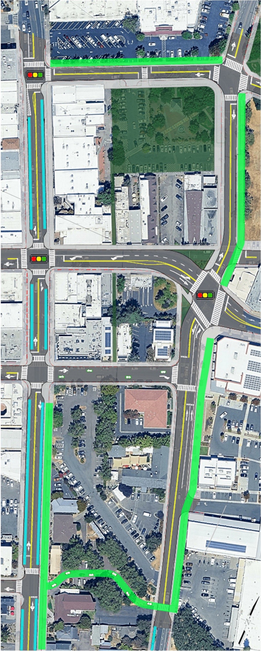
Downtown Sebastopol will transition from the one-way couplet to a two-way street system, with Main Street rebuilt as a pedestrian-oriented core and Petaluma Avenue and McKinley Street as the multimodal spine.
Main Street
Sidewalks widened on both sides, room for outdoor dining and displays, on-street parking kept but pulled back from corners for visibility under AB 413, curb extensions at intersections to shorten crossings and slow turns, street trees and lighting. Two-way traffic.
Petaluma Avenue and McKinley Street
Sidewalks rebuilt to a consistent accessible standard, and a shared-use path for two-way walking, biking, and rolling, tying directly into the Joe Rodota Trail, the Barlow, and the West County Trail. Two-way traffic.
Connecting it up
A bike-priority corridor on Burnett Street, a better link between the Joe Rodota Trail and Ives Park, and bike parking at key downtown locations. Signals upgraded and retimed to hold speeds at or below 25 mph, with leading pedestrian intervals so people crossing get a head start on turning cars.
The preferred alternative — the two-way network, the Main Street core, and the trail and bikeway connections.
Source: Fehr & Peers, Reimagining the Core final report, June 2026. Tap the plan to open it full size.
The Cross-Section
What actually changes at street level
Nothing about this requires taking property or widening the street. The right-of-way stays exactly as wide as it is today. What changes is how we divide it up.
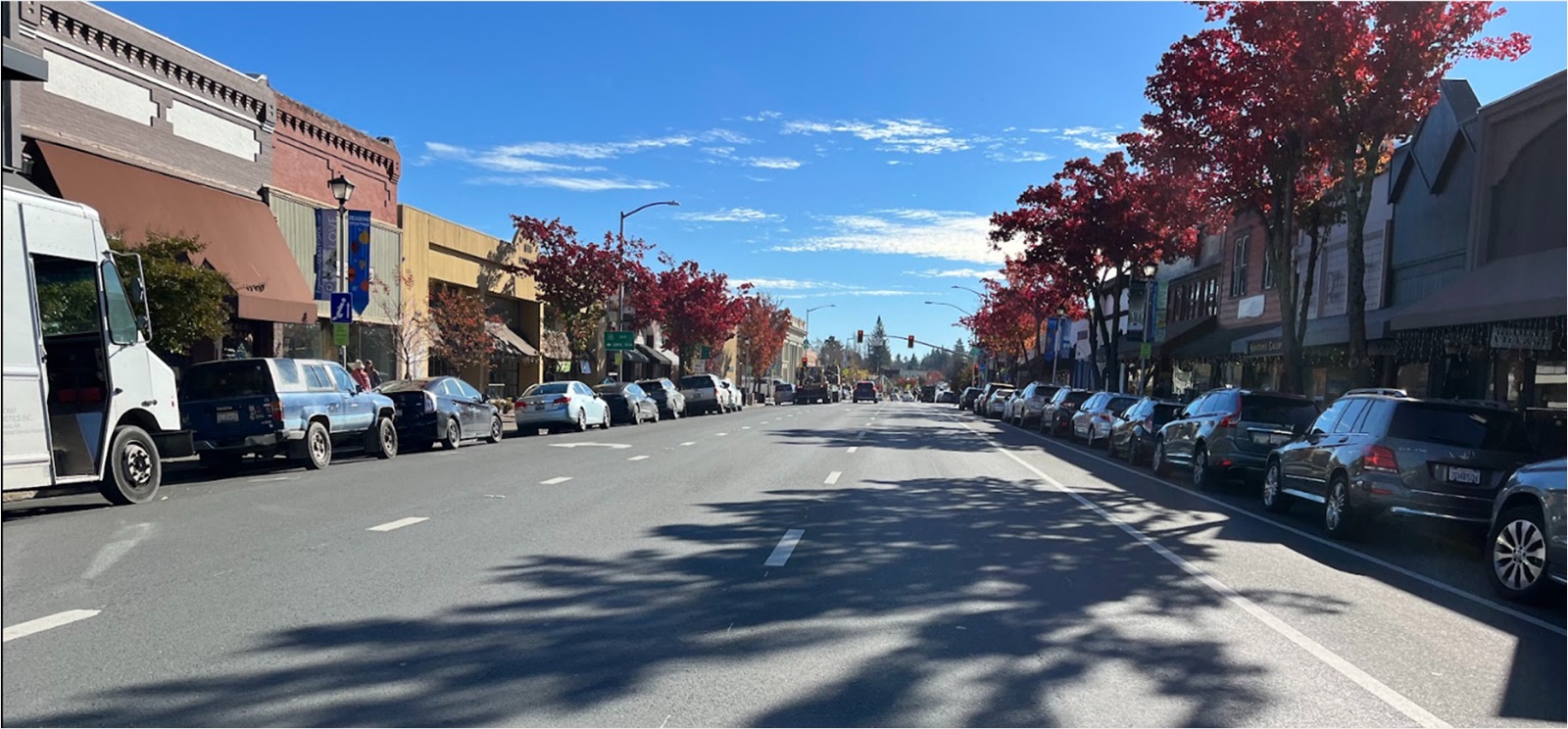
Today, most of the curb-to-curb space goes to moving vehicles in one direction. Under the plan, the travel lanes narrow — narrower lanes are one of the most reliable ways to bring speeds down, which is what actually reduces crash severity — and that recovered width goes to the sidewalk. Parking stays on both sides, because business access matters, though spaces closest to the corners come out so drivers and people crossing can see each other. That's daylighting, and it's now required under AB 413.
The wider sidewalk is the part that changes how downtown feels. It's the difference between a sidewalk you pass through and a sidewalk you linger on: room for a table outside a restaurant, a rack of goods outside a shop, a bench, a street tree, two people stopping to talk without anyone stepping into traffic.
Main Street today. Most of the curb-to-curb width goes to moving and storing vehicles.
Source: Fehr & Peers, Reimagining the Core final report, June 2026.
The Evidence
What the research says
The evidence didn't just support this direction — it settled two long-running local arguments.
The bypass question is closed
The study modeled the historical regional bypass concept again and found it diverts almost no traffic out of downtown, faces environmental and cost constraints, and wouldn't compete for funding. We can stop relitigating it.
The congestion question is answered too
Our corridors carry roughly 8,000 to 12,000 vehicles a day, modest for a state highway. What creates the friction is closely spaced intersections, turning movements, and frequent crossings, not volume. Which means you can't build your way out of it, but you can design your way to something better.
And the broader research is consistent
Speed drives crash severity, and street design drives speed far more than posted limits or enforcement. Two-way streets tend toward lower speeds, better visibility, more direct access to businesses, and stronger downtown vitality. Caltrans Design Information Bulletin 94 puts rural downtowns like ours in the category where walking is the priority mode.
The Money
How we pay for it
This is the part where good projects die, so let me be specific about the strategy.
We are not funding this out of the general fund, and we are not funding it in one piece. The project was deliberately structured into components — streetscape and sidewalks, bikeway connections, signal upgrades, two-way conversion — that can each stand alone as a grant application. That matters because different funding programs reward different things, and this project happens to check nearly every box: pedestrian and bicycle safety, VMT reduction and climate, downtown economic vitality, and converting a state highway into a context-sensitive main street in partnership with Caltrans.
The realistic sources are state and federal competitive grants for safety and active transportation, regional transportation funds through the county, Caltrans partnership on the highway side, and a local match. Because programs have different priorities, the build order will follow the money — a safety grant may deliver crossings and curb extensions first, while a climate-focused award could pull the two-way conversion forward. The design is intentionally sequence-agnostic: everything is designed to the final configuration so no early phase gets torn out later. Design once, build over time.
Local dollars matter here mostly as match, not as the main event. A modest local commitment unlocks multiples in outside funding, and a project that's already studied, designed, and community-backed scores far better than one that isn't. That's why the near-term technical studies aren't overhead — they're what makes us competitive.
The Timeline
What happens in the next 12 to 24 months
Coordination with Caltrans and regional partners. Getting this project written into the regional plans that grant programs draw from. Applying for funding. Starting the priority studies: parking and curbside management, traffic operations and signal feasibility, access management, right-of-way, and a streetscape master plan. Standing up a Downtown Implementation Advisory Group so business and property owners have a permanent seat as design advances. And putting in the low-cost safety improvements we can do now, without waiting.
My commitment. I'd rather deliver one safer crossing next year than a perfect corridor never. Follow the funding applications here, and hold me to the timeline.
The Documents
Read the study yourself
Everything on this page comes out of the Fehr & Peers final report. Both documents are posted in full — nothing here is a summary you have to take on faith.
The material below is the comparative research and case-study work that informed the direction — what happened in other cities that made this change, how the alternatives stacked up, and the primary sources. It's kept here as the record.
The Numbers
Five stats. Consistent across 20+ cities.
31%
Speed reduction after conversion
Perth, AU · Birmingham, AL
39%
Property value increase on converted streets
Louisville, KY Brook St · PVA Records
2×
Property tax revenue per block vs. one-way
Center for Sustainable Urban Neighborhoods, Louisville
10–13%
Annual retail sales growth post-conversion
Dana Point CA · Missoula MT
16%
VMT reduction per trip
JPER · Perth two-way study
The Situation
One street design. Two very different outcomes.
Sebastopol's one-way couplet was a deliberate engineering choice — and it solved the problem it was designed to solve. The study asked whether that was still the right problem to be solving. It concluded that it isn't.
What the current system was built for
The one-way couplet on Main St and Petaluma Ave was engineered to move vehicles through downtown as fast as possible. Peak-hour throughput. Minimum signal delays. That design prioritized the 7-in-10 drivers who were just passing through — not stopping, just getting from one end to the other.
What a two-way conversion is designed to do
Two-way streets redesign the same pavement for the 1-in-10 who actually want to be downtown — a customer heading to a shop, a family walking to a restaurant. Speed drops, visibility improves, and businesses become accessible from both directions. The data across 20+ cities is consistent: retail sales go up, property values go up, accidents go down.
Historical Context
One-way couplets: a mid-century idea we're ready to rethink
Sebastopol's one-way street system isn't an accident of geography — it was a deliberate design choice from a specific era of transportation thinking. Understanding that history explains why so many cities are now reversing course.
1940s – 1970s
The era that built one-way couplets
Following World War II, American cities faced a new problem: postwar automobile ownership was exploding, and existing street grids weren't built for the volume. The dominant planning response — championed by traffic engineers and the emerging Interstate highway system — was to maximize throughput. One-way couplets were a key tool: by separating opposing traffic onto parallel streets, engineers could eliminate left-turn conflicts, synchronize signals for continuous "green waves," and move more cars per hour at higher speeds. Hundreds of American downtowns were reconfigured this way between roughly 1950 and 1975.
The unintended consequences
What the traffic engineers didn't model
The throughput gains were real — but so were the costs that weren't counted. Stores became invisible to half the passing traffic. Pedestrian crossings grew longer and more dangerous as speeds increased. Drivers who missed their destination had to circle an entire block. Property values on converted streets stagnated or fell relative to comparable two-way corridors. By the 1990s, cities that had converted in the '60s were quietly converting back — and finding that the economic gains were substantial and consistent.
How It Actually Works
The traffic logic behind the conversion
The most common objection to conversion is "won't traffic get worse?" The consistent finding across converted cities is: no. Here's the logic.
Main St — for destinations
Two-way, slower speeds
Businesses visible from both directions
No more forced circling
Social promenade on west side
Petaluma Ave — natural bypass
Handles pass-through traffic
Cleaner routing for commuters
Separates destination and through trips
Both user groups win
Does the math work?
Yes — and it's been studied extensively
Urban transportation planning calls this functional classification: different road types serve different trip purposes. When a one-way couplet is converted, traffic doesn't disappear — it redistributes. The key finding from Dana Point, Louisville, Savannah, and Vancouver is that the volume feared to "back up" on local roads actually disperses more efficiently across a two-way network. Shorter circling routes mean fewer total vehicle-miles traveled.
The Sebastopol case
7:1 ratio is the key insight
Travel data shows roughly 7 vehicles pass through downtown for every 1 trying to reach a downtown destination. The current one-way couplet was designed for those 7. The conversion redesigns the street for the 1 — and routes the 7 more efficiently onto Petaluma Ave, which can serve as a natural bypass corridor. Both user groups win: commuters get a cleaner route, and shoppers get a slower, more accessible Main Street.
The promenade connection
Freed space → social infrastructure
Once through-traffic shifts to Petaluma Ave, the west side of Main Street can be reclaimed. Council Member Carter is proposing this space become a social promenade — not just a bike lane, but a linear civic space: wide enough for slow cycling, walking, outdoor dining, and spontaneous gathering. This is the model that transformed streets in European cities and increasingly in California downtowns like Dana Point.
Safety data
Slower speeds change accident outcomes
The 31% average speed reduction documented across converted cities isn't just comfort — it's survival. A pedestrian struck at 30 mph has roughly a 20% fatality risk. At 20 mph, it drops to around 5%. And the counterintuitive finding in the Louisville study is that as downtown traffic volumes increased after conversion, accidents decreased — because the streets were designed for interaction, not throughput.
Case Studies
What actually happened in other cities
These aren't projections. These are documented outcomes from cities that made this conversion. Small towns highlighted in green — they're the most comparable to Sebastopol's scale.
Dana Point, CA
California · Coastal · Highway conversion
$21M
10–13% annual sales growth. 192,000 sf new retail now supportable. PCH converted to 4 lanes (2+2). Zero net capacity loss. Now a 2028 Olympics sailing destination.
Vancouver, WA
Small Town · Broadway & Main conversion
N/A
10–20% sales growth. "Coming back to life almost overnight." Significant increase in pedestrian activity and business investment.
Louisville, KY
Small City · Brook St & 1st St · Control study
$250K
39% property value increase on converted Brook St. 2× property tax revenue vs. nearby one-way blocks. Accidents decreased even as traffic volume increased.
Lubbock, TX
Small Town · Main St & 10th St
$50K
Growth after years of decline. "Thriving — experiencing growth." One of the lowest-cost conversions with documented commercial revival.
Lafayette, IN
Small Town · Main Street
N/A
Business traffic actually picked up after conversion — counter to fears expressed before the project. A case study in pre-project concerns not materializing.
Newport, OR
Small Town · Feasibility Study
$2.7M
Economic revitalization and additional pedestrian activity documented. Promotes private reinvestment framework — public investment catalyzing private spending.
Savannah, GA
Historic Core · East Broad St
N/A
Regained most of the 2/3 of taxpaying addresses lost during the one-way era. The conversion reversed decades of fiscal damage to the city's tax base.
West Palm Beach, FL
Mid-Size City · Clematis St
N/A
Dramatic increase in new retail shops, restaurants, and property values. One of the earliest large-city examples to be widely cited in planning literature.
Toledo, OH
Mid-Size City · 3 streets
N/A
Vacant buildings occupied. "Totally turned the center city around." Often cited as the conversion that shifted professional planning consensus.
Des Moines, IA
Mid-Size City · Court & Walnut
N/A
2.08% job growth above citywide rate. Part of SDSU context-sensitive framework study examining outcomes across 6 converted cities.
Kalamazoo, MI
Mid-Size City · Proposed
Proposed
$20.6M annual sales increase projected. 36,000 sf new retail supportable. 16,000 sf new restaurant space. Model used for Sebastopol projections.
Sebastopol, CA ★
Our City · Alternative 5 / Reimagining the Core
TBD
Associated with higher retail activity and downtown vitality per Reimagining the Core study. Caltrans grant-funded engineering analysis underway through Fehr & Peers, 2025–2026.
Honest Assessment
Strengths, weaknesses, opportunities, threats
This isn't a slam dunk. There are real tradeoffs. Here's a frank accounting of where the conversion is strong, where it's vulnerable, and what has to go right for it to work.
SStrengths
Speed calming — 35–40 mph → 20–25 mph documented
Retail visible from both directions, doubling exposure
39% property value increase on converted streets (Louisville)
16% VMT reduction per trip — direct climate benefit
Proven in 20+ cities with consistent outcomes
Low cost relative to impact ($250K–$21M range)
Supports west-side Main St social promenade (Alt. 5)
Reduces forced circling — more direct access for all users
WWeaknesses
Construction disruption — temporary service impacts
Signal retiming required across couplet
Driver adjustment period — new routing habits take time
Some Level of Service reduction at peak hours
Delivery vehicle access may need coordination
Requires careful phasing to minimize business impact
Caltrans jurisdiction on Hwy 116/12 requires state approval
Political timing — council transitions during long process
Cost escalation if project delayed (12.5%/yr construction inflation)
Community fatigue from prior studies without action
Funding gap if EIFD or grant timing misaligns
The Plan
Alternative 5 — Modal Separation
A four-part framework for a safer, more productive, more connected downtown Sebastopol — advocated by Council Member Phill Carter as the direction for deeper engineering study by Fehr & Peers.
1
Two-Way Conversion
Petaluma Ave + Main St: bidirectional
Speeds slow — businesses visible both ways
No more forced circling around blocks
Direct access to destinations
2
West-Side Main St Social Promenade
A linear social space on the west side of Main St
Space to linger, meet neighbors, support nearby businesses
Outdoor dining, seating, and gathering
Makes downtown a destination, not just a corridor
3
Pedestrian Realm
Wider sidewalks + improved crossings
Space for outdoor dining and gathering
Accessible, comfortable downtown environment
Street trees, seating, place-making elements
4
Trail Network Connection
Links to West County Trail
Protected bike infrastructure through downtown
Connects residential neighborhoods to downtown businesses
Regional trail-to-downtown access
California Blueprint
Dana Point Lantern District
Same challenge as Sebastopol: a state-built one-way couplet prioritized regional throughput and fragmented a downtown. Here's what they did — and what happened.
EngineeringPCH converted to 4 lanes (2+2 split). Del Prado Avenue became a 2-lane collector. Same total capacity — entirely different character.
Capacity6 total lanes maintained. Zero net capacity loss. The "we can't lose throughput" objection was answered directly in the design.
Cost savings$3M saved through value engineering. Sidewalks preserved at 8 ft minimum in front of all businesses. The project demonstrated fiscal discipline.
California lawNavigated Coastal Act, CEQA, and multiple Coastal Development Permits. Complex California regulatory environment — and it got done.
Timeline2008 plan → construction → opening → now a 2028 Olympics sailing venue. Long arc, but it happened.
$21M+Public infrastructure invested
6 lanesMaintained — zero capacity loss
10–13%Annual retail sales growth
192K sfNew retail space now supportable
2028Olympics sailing destination — Lantern District is the backdrop
Fiscal Logic
How conversion pays for itself
Property value increases aren't just a livability metric — they generate the tax increment that funds the investment. This is the self-reinforcing logic that makes conversion attractive fiscally, not just urbanistically.
39%
Property value increase on converted streets. One-way street blocks declined in value over the same period.
University of Louisville / Property Valuation Administration records
2×
Property tax revenue per block on two-way streets vs. comparable one-way blocks in the same neighborhood.
Center for Sustainable Urban Neighborhoods, Louisville
EIFD
Enhanced Infrastructure Financing District captures property tax increment from rising values — directly funding the infrastructure that created them. Already under discussion for West County corridor.
California EIFD statute · AB 229 / SB 628
$1M+
Estimated annual property tax revenue left on the table in Louisville by maintaining multi-lane one-way streets. Sebastopol's scale is smaller — but the ratio holds.
Gilderbloom & Riggs · Planetizen / University of Louisville
Full Record
Documented outcomes — all 20+ cities
Green = Small Town · Gold = California · Highlighted = Sebastopol. Sources: SDSU / Riggs & Appleyard, Dana Point EIR, Strong Towns, ResearchGate, City studies.
City
Type
Est. Cost
Outcomes
Dana Point, CA
California
$21M
10–13% annual retail sales growth · 192K sf new retail supportable · 2028 Olympics venue · zero capacity loss
Vancouver, WA
Small Town
N/A
10–20% sales growth · "coming back to life almost overnight" · significant private reinvestment
Louisville, KY
Small City
$250K
39% property value increase · 2× property tax/block · traffic accidents ↓ even as volume increased
Lubbock, TX
Small Town
$50K
Growth after years of decline · businesses thriving · one of lowest-cost conversions with documented commercial revival
Regained 2/3 taxpaying addresses lost in one-way era after 2012 reconversion
West Palm Beach, FL
Mid-Size City
N/A
Dramatic ↑ in new retail shops, restaurants, and property values
Toledo, OH
Mid-Size City
N/A
Vacant buildings occupied · "totally turned the center city around"
Lafayette, IN
Small Town
N/A
Business traffic picked up after conversion — counter to pre-project fears
Missoula, MT
Small City
N/A
10–13% short-term retail benefit expected · part of national pattern analysis
Kalamazoo, MI
Mid-Size City
Proposed
$20.6M annual sales increase projected · 36K sf new retail · 16K sf new restaurant space supportable
Birmingham, AL
Mid-Size City
N/A
Speed friction ↓ · revived downtown efficiency · simulation-based study
Perth, AU
International
N/A
31% speed reduction · easier navigation for residents and businesses
Durham, NC
Mid-Size City
$12M
Planned ↑ for pedestrians, cyclists, and businesses · RAISE grant funded
Des Moines, IA
Mid-Size City
N/A
2.08% job growth above citywide rate · part of SDSU 6-city economic study
Sebastopol, CA ★
Our City
TBD
Associated with higher retail activity + downtown vitality · Caltrans grant funded · Reimagining the Core study 2025–2026
Green = Small Town · Gold = California · Highlighted = Sebastopol
Do Your Own Research
Primary sources & further reading
The case for two-way conversion is well-documented in transportation literature spanning 30+ years. Here are 20 sources behind this analysis — and search terms to find more.
Suggested search terms — start here
"one-way to two-way conversion" case studies downtown"one-way couplet" "two-way" history economics"street conversion" "property values" "retail sales" studyDana Point "Lantern District" conversion before afterLouisville "one-way to two-way" "Brook Street" economics
Add NCHRP, ITE Journal, Transportation Research Record, Strong Towns, NACTO to find peer-reviewed and practitioner sources.
Rigorous economic analysis by William Riggs advancing a context-sensitive framework. The source for most of the retail sales and property value data cited here.
A skeptical take from a free-market transportation perspective. Worth reading to understand the strongest counterarguments and how they've been addressed in practice.